KANSAS CITY — An extremely active jet stream in North America this winter has brought an ever-changing pattern to the weather. Frequent rain and snow episodes have occurred while bouts of impressive cold and some unusual warmth have all helped to characterize this winter. World Weather, Inc. suggests that the fun is not over and that more of the same is to be expected through March and into April. The only change will come from seasonal warming that may help reduce the incidence of extreme cold and may shift the wettest conditions northward, but a calming of the pattern is very unlikely.
The lunar cycle correctly predicted this pattern. With help from the warm pool of water in the Gulf of Alaska, El Niño and the Polar Vortex there have been many surprises to the vibrancy of this year’s winter pattern. Extreme low temperatures in February below -50 degrees Fahrenheit in the upper Midwest and some impressive snowfall and blizzard conditions also occurred, along with at least one recent ice storm. Even lackluster weather in California disappeared during the heart of winter with numerous storms affecting the Sierra Nevada with snowfall large enough to measure in feet multiple times. Record-setting snowfall in the Seattle area has rounded out the list of amazing weather noted so far this winter.
The frequent bouts of snow, rain and ice storms in the Midwest have left the soil saturated over almost the entire eastern half of the United States. Flooding was noted in the past few weeks in the Ohio, Tennessee and lower Mississippi River basins as well as the northeastern United States and southeastern Canada.
It is not unusual to see large parts of the eastern United States with saturated soil in mid-to-late winter, but recent flooding was a concern. Some wheat fields were damaged, and with ongoing cool weather into the first week of March it is quickly becoming a general consensus that at least some spring planting will be delayed this year.
The delay in planting is expected with the knowledge that the next few weeks will bring a continuation of the active weather pattern that has been plaguing the United States and southeastern Canada since November. The weather pattern is not significantly different from that of 1983, 2001 or 1965, and in each of those years the active jet stream proved to be quite resilient through the balance of winter and into spring.
World Weather, Inc. sees little reason to anticipate a sudden change in the pattern. The only weather feature that will be going away in the balance of February and March will be the Polar Vortex. That means the jet stream may not be suppressed as far to the south as long as it has been recently. February will end with cooler-than-usual air present in much of the contiguous United States and across portions of Canada. As March rolls around, Canada and the northwestern United States will begin warming. Cool air will be trapped lingering in the Midwest, Great Plains and interior southeastern states.
A big shift toward warmer weather is expected in the second week of March that will bring warmer air back to many areas in North America. The returning warmer air will allow the jet stream to shift northward. That likely will take the path of greatest precipitation farther north as well.
Frequent bouts of rain and some occasional snow will fall from the southwestern United States across the central and northeastern Plains to the Midwest. The pattern will include the drier biased areas in the southwestern Plains, bringing them some needed relief to recent dryness. The change also will suppress southeastern U.S. rainfall for a while. The wettest conditions will shift northwest to include many Midwestern locations.
Flooding that was common in early-to-mid-February during the early-to-middle part of February will slowly abate in late February, but it may show itself again a little later this spring in slightly higher latitudes.
 World Weather, Inc. expects the most active part of the region’s weather pattern to cycle around again in late March, April and early May. Flooding may start out in some of the same areas impacted during February, but as time moves along it likely will dominate the western and upper portions of the Midwest.
A short-term bout of drying is expected in the final days of February and early March in the lower Midwest, Tennessee River basin and Delta. That will bring about the end of flooding “temporarily,” and get soil conditions to begin improving for the early season planting. About the time that spring planting becomes aggressive in the mid-south parts of the United States the rainy pattern is likely to resume again. This will delay some of the corn, soybean other crop planting in the Delta, Tennessee River basin and lower Midwest. The planting delays in these areas will not be as persistent or significant as those expected in the central and northern Midwest in the heart of the spring planting season.
Too many delays in early- and mid-season planting across the Midwest, Delta and Tennessee River basin may bring some greater interest back to the commodity futures trade as investors and speculators begin to debate the potential size of the new U.S. crops. Significant planting delays could reduce the outlook for corn and increase the size of this year’s soybean acreage.
In the meantime, a short-term increase in El Niño development is forthcoming in March and April as warming subsurface ocean temperatures in the equatorial tropical Pacific Ocean are lifted toward the surface of the ocean. The expected warming will return El Niño-like conditions to many places in the World. For the United States, that restores a wetter biased pattern farther south in the nation, returning rainy weather to the lower Midwest, Delta and Tennessee River basin. The return will occur while spring weather is most active.
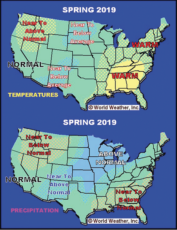
The returning wet bias in the interior southern United States may come with a greater incidence of severe thunderstorms and a short-term bout of cool and dry air returning to the northern Plains, Canada’s Prairies and the upper Midwest. These conditions also will reinforce the official spring outlook calling for a wetter biased spring from the southern Rocky Mountain region to the entire Midwest. The southeastern states likely will acquire a drier and warmer weather bias while the Pacific Northwest trends a little drier and warmer as well.
In the meantime, what about South America weather? Have crop conditions improved after the dismal start to the growing season? World Weather, Inc. believes they have, and second season corn production in Brazil will have sufficient rain to support a good crop with high yield potentials. Early season corn and soybeans did not fare quite as well in Brazil due to dryness during early summer. Most of the losses in Brazil have been digested by the marketplace, and much improved production from Argentina this summer versus last summer will see to it that South America’s contribution to world oilseed production will be sufficiently high once again, despite Brazil’s production issues.


