Have you ever had a painful annoying rash on an arm or leg that just would not go away? That must be how some of this year’s farmers are feeling about the 2019 crop. After an admiral effort to plant crops extremely late following one of the wettest springs in recorded history, it has been one thing after the other that has prevented crops from developing as well and as fast as desired.
Harvesting is underway, but the lack of normal autumn weather has led to cool temperatures, low evaporation rates and additional precipitation, all of which have slowed this year’s harvest. The farmers have the “itch” to get this crop out of the fields and out of the history books, but World Weather, Inc. believes this agricultural rash is going to linger for quite a while longer.
Ocean surface temperatures in the northeastern Pacific Ocean are still incredibly warm, although some cooling has occurred near the British Columbia and U.S. Pacific Northwest coast in recent weeks. The unusually large area of warm ocean surface water already has played a huge role in steering much colder air into the central part of North America. The earlier-than-usual blizzards of September in southwestern Canada’s Prairies and that of October in the Dakotas into southeastern Canada’s Prairies have been followed by several bouts of impressive cold, none of which were more potent than that which occurred recently in the central United States.
Storm sizes have been reduced in recent weeks due to colder inland temperatures, but the cold has slowed drying rates. Many U.S. farms have wet field conditions, and unharvested crops are still carrying too much moisture to be stored. The drying process for harvested grain and oilseeds has slowed down the harvest pace. Meanwhile, the recent propane shortage has added to the pain of getting this year’s crops out of the fields.
Ideally, the weather doctor needs to prescribe a two-to-three-week window of dry and warm weather accompanied by some breezy conditions at times. That environment would help to dry down the soil and dry out crops in the fastest way possible, but such a stretch of fine autumn weather is going to be very hard to find.
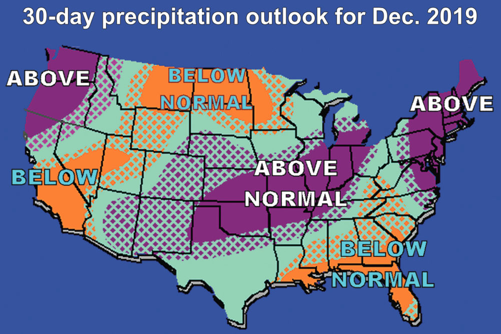
Do you remember that warm water mentioned previously in the northeastern Pacific Ocean? When the jet stream shifts seasonally southward storm systems moving through the cold air aloft and over the warm oceans below will grow larger and more powerful than usual, bringing greater storminess to portions of the United States. The intensity of storm systems and the amount of precipitation that impact key crop areas largely will be determined by how much cold air comes southward through Canada to the heart of the United States.
The more cold air that comes southward over the next several weeks the less intensive storm systems will be because the cold dry air coming southward will suppress storm development. The greatest fear about late November and December, however, is that the cold feed from northern Canada will not be nearly as significant as it has been, and that will allow a southern branch of the jet stream to become more active. Storm systems moving across the Pacific Ocean will move into the southwestern United States and then to the central Plains and Midwest. The storm paths will be such that warm moist air will be drawn northward from the Gulf of Mexico while cold, dry, air is drawn southward from Canada. The clash in airmass temperatures will the significant enough for storm center development. However, the storms coming into the southwestern United States will have greater-than-usual moisture entrained in them because of the warm ocean temperatures. As each system comes into the middle of the United States there is likely to be a large rain, snow and freezing rain event.
The succession of storm systems is expected to be frequent during December, and there is some concern that it could start a little early. The frequent occurrence of storm systems moving across the central U.S. would be bad enough in the middle of winter when you would expect such conditions, but farmers are still trying desperately to get their crops off and this is not going to help one bit. Farmers will need to work swiftly in the next few weeks to beat the more frequent storm pattern that is coming in December, but they may be up against a proverbial wall because of delays in artificially drying this year’s crops prior to storage or processing. The slower harvest pace because of drying issues could prolong the late harvest just long enough to miss the best opportunity for fieldwork in the next two to three weeks.
Weather in late November and early December is not likely to be ideal, but it may be just good enough to get some farmers back into their fields. This meteorologist makes no promises of extended periods of warm weather without precipitation this year because there is too much energy in the atmosphere, too much cold air in the arctic and Canada, and moisture coming in from the Pacific Ocean and Gulf of Mexico will be too abundant to suggest a fine finish. So, the crop year that started as a serious challenge is expected finish in the same manner.
In the meantime, weather anomalies elsewhere in the world are stagnating. Crop areas from Romania and Bulgaria through Ukraine to Kazakhstan have been fighting drought since last spring. There were some short-term bouts of timely precipitation, but the winter crops may not be as well established as usual.
Australia’s severe drought is coming up on its three-year anniversary and there is very little sign of change coming through the end of November and the first half of December. The same can be said for some of the crop areas in southern Indonesia, where dryness remains a serious concern. Some forecasters have started talking about El Niño returning in 2020. If they are correct, drought in Australia and Indonesia may be far from over, but the jury is still out on some of those El Niño forecasts.
Northeast Brazil also is enduring drought while southwestern Argentina has seen bouts of limited rain in recent weeks. Argentina’s dryness is not nearly as significant as that of eastern China, where winter rapeseed and some unirrigated wheat are not establishing well and need moisture soon.
The remainder of Brazil and Argentina weather is looking good for summer grain and oilseed development, and the same is possible in South Africa as its seasonal rains begin. India likely will have a tremendous winter crop after an unusually long monsoon season. Unfortunately for some U.S. producers the good weather in some of these areas will not give them better prices for their delayed harvest, and that only makes the agricultural rash more uncomfortable.